GeoSection AutoCAD 4.1

A program to create topographic designs.
GeoSection AutoCAD is aimed at topographic designs for use in construction. It links itself to AutoCAD.
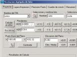
GeoSection AutoCAD is an application that is hihgly useful for those professionals in construction who need to make topographical studies and designs. You can control the different lines and polygons; draw level curves, points, vertices, digital terrain models, and transversal sections; generate communication route projects; specify the distinct levels of agricultural terrain; calculate the volumes between transversal sections; generate polygonal designs, etc.
It also comes equipped with other tools to make notifications, associate a defined floor axis with a longitudinal profile file, tag level curves, etc. In other words, GeoSection AutoCAD is everything a good topographer could need.
DownloadGeoSection AutoCAD 4.1 related downloads


ACDSee Photo Manager 18
 Download
International versions of this excellent image administrator and viewer, with many supplementary functions.